Historic Callander
On the UK ordnance survey map, grid reference NN 629 079 you will find Callander, right on the Highland Boundary Fault - where the Highlands lie to the north where and Ben Ledi, Callander's own mountain, provides a beacon to lead you. The terain around Callander is largely formed by 'pudding stone' whichis the local stone used to build the older houses in the town. The glaciers of the many ice-ages gouged out the long glens containing loch Doine, Loch Voil and Lubnaig and finally 'bulldozed' the glacial debris down just south of Callander to form the terminal glacial moraine in a sweeping horseshoe shape. The morain starts behind the golfcourse, passes just north of Auchenlaich farm and the gravel pits, was cut by the A84 before curving over to river Teith. The glacial 'Esker' the Victorians took to be a Roman camp is the bed of a river which flowed under the glacier.
The pre-historic occupants of the area have left lots of evidence of their passing. There are 3 hillforts - the most prominent one to the west of Callander at Dunmor hill. There is also the ancient 'Auchenlaich long barrow', one of their burial places, and more recently archaeologists have unearthed the remains of a circular hut near to Claish Farm south of the river.
Callander appears to have been an important religous centre.'Tom na Chessaig' where legend tells us St Kessog preached in the open air is beside the river Teith at Callander Meadows. Kilmahog was the 'Cell of St Chug' and just a little way north at the Leny Pass is the little Chapel of St Bridget where the forebears of America's President McKinley were buried.
The Victorian railway engineers built the Callander -Oban railway line right through the remains of some earthworks which represent the Roman Marching Camp on the west side of the river between Callander and Kilmahog.
In the area around Callander, there were many clans, the most prominent of these being the Clan Buchanan, whose ancient burial ground lies beside the confluence of the two rivers northwest of the town, and whose cheiftain occupied Leny House between Callander and Kilmahog. To the north in the highlands were the Stewarts, the McLarens and the MacGregors. Most visitors have heard of Rob Roy McGregor and many visit his grave in Balquhidder
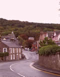
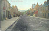
The oldest part of Callander is beside the river at Bridge Street, but after the 1745 Jacobite rising, the Commissioners for the Forfeited Estates created a new 'Callander Town' with its broad Main Street - Callander's shopping area. Around 1770 the first bridge was built over the river Teith and Bridgend became part of the town.
At the end of the seven years war in 1763 a Soldiers Settlement was established in Callander in an area which is now part of the Golf Course. Also, families from the nearby Highland Glens settled in the town and its environs and the variety of trades and occupations increased, including: spinning and weaving, merchandising, shoemaking and tailoring.
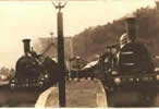
About 150 years ago the Callander to Oban railway line arrived. This brought the first tourists to the area and popularised the Trossachs which were further promoted with the publication of Scott's 'Lady of the Lake'. An engineer who helped plan the railway line saw the potential of the town and bought the land now known as 'Leny Feus'. On this land he built a number of large stone villas which were bought by affluent businessmen for the purpose of providing their families with a holiday retreat in the midst of this magnificent scenery. Leny Fues is still considered to be the 'affluent' end of town. The railway line was closed by a rockfall at GlenOgle just before it was due to be closed by the 'beeching Axe' in the 60s.
In 1962 Callander's fame grew further with the BBC TV series 'Doctor Finlay's Casebook. The good doctor's house, 'Tannochbrae' is now a local guest house which proudly boasts momentos of the series.
Callander homepage AccommodationCallander activities Trossachs activities Maps |
|---|